
Development of an optimized, combined and high-resolution imaging method for the site investigation of radioactive repositories (DOSIS)
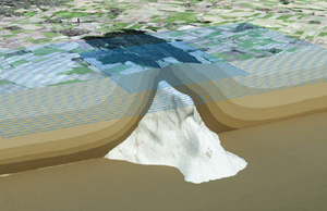
Asse with a schematic section through the subsurface.
The modelled salt structure is shown in white. (Source: BGE)
in the area of the “Asse” salt structure.(Source: BGE)
3D seismic measurements are a tool for high-resolution structural exploration of the subsurface using artificially generated seismic waves. Depending on the acquisition geometry and the seismic source, structures can be examined at depths ranging from a few meters to more than 10 km. The accuracy of the geological layer boundaries in the depth image resulting from the field data depends heavily on the quality and the details of the physical earth model and the imaging algorithms used. The "DOSIS" project was initiated in order to design an optimized, combined and high-resolution method to facilitate finding answers for important geophysical and geological questions in the exploration of repository sites in Germany in the future. The project is financed and managed by the Bundesgesellschaft für Endlagerung (BGE). Academic project partners are the "Applied Geophysics" working group at the Karlsruhe Institute of Technology (KIT), which contributes research and software in the field of seismic wave modelling using finite differences and full waveform inversion, and the "Seismics" working group at the TU Bergakademie Freiberg (TUBAF), which deals with further development of the so-called Fresnel-volume migration. The BGE provides the high-quality 3D seismic data acquired in 2020 in the area of the "Asse" salt structure in Lower Saxony, which can be used to test new methods and procedures.
Finite-difference modelling and full-waveform inversion
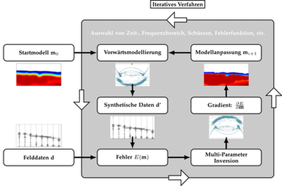
By performing these steps iteratively, a model is found
that describes the measured data. (Source: GPI KIT)
The principle of full-waveform inversion (FWI) is based on a computer simulation of seismic data in a given earth model using the acquisition geometry applied in the field. The data simulated by finite-difference (FD) modelling are then compared with the measured field data - deviations between the data sets are attributed to an incorrect earth model. Based on the difference in the data sets, the earth model can now be improved using a computationally intensive algorithm. This process of simulating seismic data, comparing them with the field data and updating the earth model is repeated until the difference between the simulated data and the field data is as small as possible and the determined earth model is therefore deemed to be best. In contrast to classic traveltime tomography, FWI not only uses the traveltimes of the seismic waves (phase) but also their amplitudes, such that the best possible match of the data in phase and amplitude is achieved in a suitable time window up to a certain frequency. This method allows earth models of physical parameters to be determined with better resolution than classic tomography could achieve. In this context it is obviously important to make the computer simulation of seismic data realistic and to take important physical phenomena such as anisotropy or attenuation into account.
Fresnel-volume migration
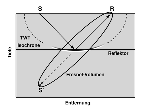
migration. The imaging is restricted to the part of the two-way traveltime
isochrone that lies within the Fresnel volume. (Source: TUBAF)
Fresnel-volume migration (FVM) is based on the classic Kirchhoff migration method. In contrast to Kirchhoff migration, however, amplitudes of the seismic data set that has to be migrated are not distributed along complete isochrones (surfaces of equal traveltime), but the migration operator is limited with the help of Fresnel volumes to the physically relevant part around the actual reflection point. For this purpose, the emergence angle of waves at the receiver must first be determined from the field data. This allows directed rays to be propagated back into the subsurface as part of the imaging algorithm and thus to concentrate mainly on the coherent wavefield components during a migration. This method therefore enables focused images with an improved signal-to-noise ratio, even of steep and complex structures such as the flanks of salt bodies or faults, as can be found in the "Asse" area.
Project goals
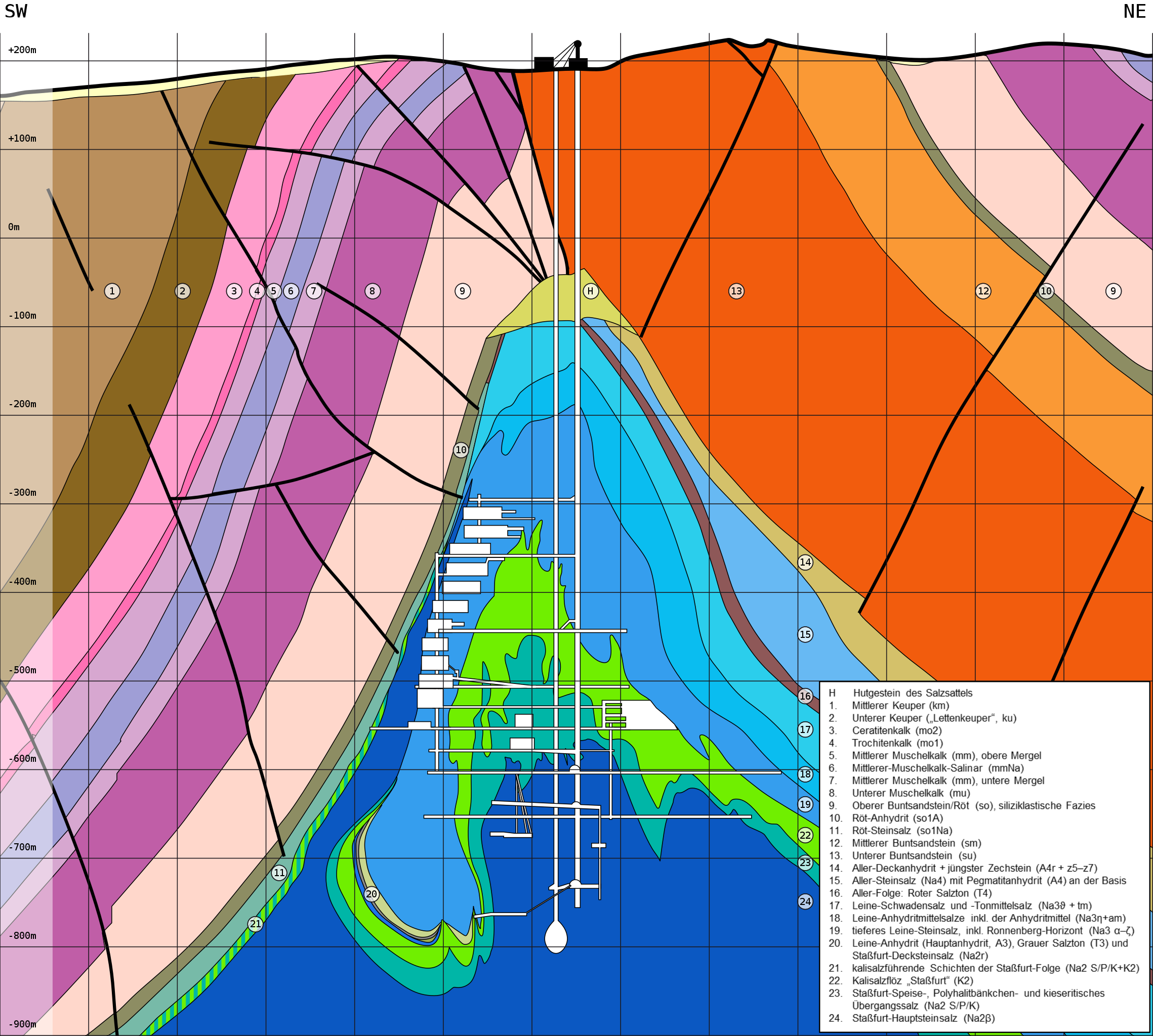
steep flanks of the salt structure and the faults in the sediment layers overlying the
salt. (Source: after Thömmes & Gömmel, 2004, and Szymaniak & Schäfer, 2002)
In the framework of the "DOSIS" project, the simulation of elastic waves using finite differences and the associated full-waveform inversion as well as the Fresnel-volume migration are further developed, so that anisotropy (directional dependence of physical parameters such as the propagation velocity of seismic waves) as well as inelastic attenuation can be taken into account for a detailed characterization of the complex geology in the "Asse" area. The optimized combination of these methods should make it possible to reconstruct multi-parameter models (P- and S-wave propagation velocity, density, quality factors to describe inelastic attenuation and anisotropy parameters) with high resolution and to test them as efficiently as possible in order to obtain a detailed and accurate structural depth image of the subsurface. It is expected that, compared to classic depth imaging methods, the improved spatial resolution of the physical parameters and the well-focused structural image will provide new insights into the geological structure below the "Asse", in particular into the exterior form of the salt structure and the flank areas of the salt saddle, but possibly also into the presumably very heterogeneous areas inside the salt structure. Furthermore, multi-parameter imaging allows, ideally, for an improved rock characterization with regards to the state of stress (anisotropy) and an illustration of possible fluid pathways (Poisson's ratio, attenuation). The method also allows the determination of elastic moduli of the subsurface based on seismic measurements at the earth's surface. In the future, the results can play an important role in answering various geoscientific questions, for instance related to the assessment and analysis of the stress state or the occurrence of microseismicity, and provide additional information for a joint interpretation. Furthermore, together with other geoscientific and geotechnical investigations, they form an important basis for the planning of the retrieval of radioactive waste from the nuclear repository "Asse" by allowing a more accurate determination of the position of interfaces and the characterization of heterogeneities. The methods and procedures developed in this project as well as the experience gained through tests can be used in future explorations of other locations of host rocks like salt in shallow deposits, salt in steep deposits and clay rock.
Project partners and contacts
Bundesgesellschaft für Endlagerung mbH, Eschenstraße 55, 31224 Peine – Contact: Maximilian Scholze
Karlsruher Institut für Technologie, Kaiserstr. 12, 76131 Karlsruhe – Contact: Dr. Lars Houpt, lars.houpt∂kit.edu
Technische Universität Bergakademie Freiberg, Akademiestr. 6, 09599 Freiberg – Contact: Prof. Dr. Stefan Buske; buske∂geophysik.tu-freiberg.de
References
· Achim Thömmes, Reiner Gömmel (eds., 2004): Schachtanlage Asse (leaflet). GSF-Forschungszentrum für Umwelt und Gesundheit, Remlingen
· Tanja Szymaniak, Michael Schäfer (2002): Geologisch-tektonische Kartierung der Salzstruktur Asse im Subhercynen Becken. Graduate mapping, Technische Universität Clausthal, Institut für Geologie und Paläontologie, Clausthal-Zellerfeld