
Deep Structure of the Central Upper Rhine Graben (TIMO)
 The Upper Rhine Graben (URG) in Southwest Germany is a branch of the European Cenozoic Rift System. The natural seismicity in the region is moderate, however, the seismic hazard for the about 6 million people in the region may be significant due to the high concentration of inhabitants, infrastructure and industry. As there are still few and only coarse data-based models for the deep structure of the URG, the TIMO project (Tiefenstruktur des mittleren Oberrheingrabens – Deep Structure of the Central Upper Rhine Graben) is conducted to improve the resolution of the subcrustal lithosphere and asthenosphere. This will allow us a better understanding of the geodynamic evolution as well as provide constraints for seismic hazard evaluation. From December 2004 until May 2006 a passive seismological experiment was conducted with 32 mobile KABBA stations together with permanent broadband and short-period stations. A study of the local seismicity indicates normal faulting across the entire crust inside the central URG. The determined anisotropy in the upper mantle shows only a smooth variation of the direction with fast wave propagation which is mainly in northeast-southwest direction. This pattern is interpreted as preferred mineral alignment in the upper mantle due to flow-induced shearing. An anomaly in anisotropy associated with the URG could not be found. The analysis of teleseismic wavefront perturbations also revealed no subcrustal anomaly. However, there may be an anomaly with reduced seismic velocity inside the upper crust in the area of Landau which coincides spatially with a heat flow anomaly.
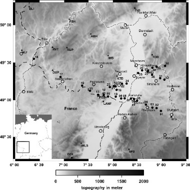